
Potes topographic map
Interactive map
Click on the map to display elevation.
About this map
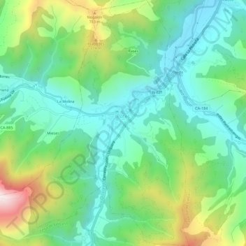
Name: Potes topographic map, elevation, terrain.
Location: Potes, Liébana, Cantabria, Cantabrie, 39570, Espagne (43.13238 -4.64489 43.17275 -4.60865)
Average elevation: 1,608 ft
Minimum elevation: 830 ft
Maximum elevation: 3,435 ft
Other topographic maps
Click on a map to view its topography, its elevation and its terrain.
Bejes
Espagne > Cantabria > Liébana > Cillorigo de Liébana > La Quintana
Bejes, La Quintana, Cillorigo de Liébana, Liébana, Cantabria, Cantabrie, 39580, Espagne
Average elevation: 2,644 ft