
Mole Creek topographic map
Interactive map
Click on the map to display elevation.
About this map
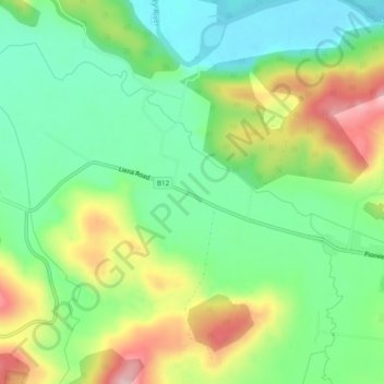
Name: Mole Creek topographic map, elevation, terrain.
Location: Mole Creek, Devonport, Tasmania, 7310, Australia (-41.56531 146.35161 -41.53561 146.39958)
Average elevation: 860 ft
Minimum elevation: 584 ft
Maximum elevation: 1,322 ft
Other topographic maps
Click on a map to view its topography, its elevation and its terrain.
Coles Beach
Australia > Tasmania > Devonport
Coles Beach, Devonport, City of Devonport, Tasmania, 7310, Australia
Average elevation: 49 ft
South Spreyton
Australia > Tasmania > Devonport
South Spreyton, Devonport, Kentish, Tasmania, Australia
Average elevation: 505 ft
Mole Creek Karst National Park
Australia > Tasmania > Devonport
Mole Creek Karst National Park, Western Bluff Track, Mayberry, Devonport, Tasmania, 7310, Australia
Average elevation: 2,054 ft
Mount Roland
Australia > Tasmania > Devonport
Mount Roland, Kentish, Tasmania, Australia
Average elevation: 2,703 ft
Ferny Creek
Australia > Tasmania > Devonport
Ferny Creek, Devonport, Tasmania, 7310, Australia
Average elevation: 2,234 ft
Gawler River
Australia > Tasmania > Devonport
Gawler River, Devonport, Tasmania, 7310, Australia
Average elevation: 446 ft
Bakers Beach
Australia > Tasmania > Devonport
Bakers Beach, Devonport, Tasmania, 7310, Australia
Average elevation: 361 ft