
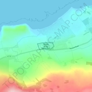
Heads of Ayr Farm Park topographic map
Interactive map
Click on the map to display elevation.
About this map
Name: Heads of Ayr Farm Park topographic map, elevation, terrain.
Average elevation: 197 ft
Minimum elevation: 0 ft
Maximum elevation: 725 ft
Other topographic maps
Click on a map to view its topography, its elevation and its terrain.
Dailly
Vereinigtes Königreich > Schottland > South Ayrshire
Dailly, South Ayrshire, Schottland, KA26 9SD, Vereinigtes Königreich
Average elevation: 308 ft
Straiton
Vereinigtes Königreich > Schottland > South Ayrshire
Straiton, South Ayrshire, Schottland, KA19 7NF, Vereinigtes Königreich
Average elevation: 610 ft
Dunure
Vereinigtes Königreich > Schottland > South Ayrshire
Dunure, South Ayrshire, Schottland, KA7 4LR, Vereinigtes Königreich
Average elevation: 226 ft
Troon
Vereinigtes Königreich > Schottland > South Ayrshire
Troon, South Ayrshire, Schottland, KA10 6AZ, Vereinigtes Königreich
Average elevation: 36 ft