
Moja topographic map
Interactive map
Click on the map to display elevation.
About this map
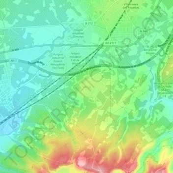
Name: Moja topographic map, elevation, terrain.
Location: Moja, Olèrdola, Alto Penedés, Barcelona, Cataluña, 08720, España (41.30476 1.66975 41.34476 1.70975)
Average elevation: 692 ft
Minimum elevation: 522 ft
Maximum elevation: 1,037 ft
Other topographic maps
Click on a map to view its topography, its elevation and its terrain.
Sant Pere Molanta
España > Cataluña > Alto Penedés > Olèrdola > Sant Pere Molanta
Sant Pere Molanta, Olèrdola, Alto Penedés, Barcelona, Cataluña, 08798, España
Average elevation: 768 ft