
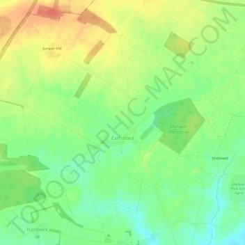
Cottisford topographic map
Interactive map
Click on the map to display elevation.
About this map
Name: Cottisford topographic map, elevation, terrain.
Average elevation: 397 ft
Minimum elevation: 322 ft
Maximum elevation: 479 ft
Other topographic maps
Click on a map to view its topography, its elevation and its terrain.
Ambrosden
United Kingdom > England > Oxfordshire > Cherwell District
Ambrosden, Cherwell District, Oxfordshire, England, United Kingdom
Average elevation: 217 ft
Launton
United Kingdom > England > Oxfordshire > Cherwell District
Launton, Cherwell District, Oxfordshire, England, United Kingdom
Average elevation: 240 ft
Kirtlington
United Kingdom > England > Oxfordshire > Cherwell District
Kirtlington, Cherwell District, Oxfordshire, England, United Kingdom
Average elevation: 292 ft
Deddington
United Kingdom > England > Oxfordshire > Cherwell District
Deddington, Cherwell District, Oxfordshire, England, United Kingdom
Average elevation: 351 ft
Bicester
United Kingdom > England > Oxfordshire > Cherwell District
Bicester, Cherwell District, Oxfordshire, England, United Kingdom
Average elevation: 249 ft
Adderbury
United Kingdom > England > Oxfordshire > Cherwell District
Adderbury, Cherwell District, Oxfordshire, England, United Kingdom
Average elevation: 328 ft
Banbury
United Kingdom > England > Oxfordshire > Cherwell District
Banbury, Cherwell District, Oxfordshire, England, United Kingdom
Average elevation: 381 ft