
Tinghir topographic map
Interactive map
Click on the map to display elevation.
About this map
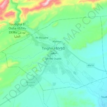
Name: Tinghir topographic map, elevation, terrain.
Average elevation: 4,436 ft
Minimum elevation: 3,930 ft
Maximum elevation: 6,709 ft
Tinghir est située entre les montagnes du haut Atlas et celles de Saghro, elle est perchée à plus de 1 300 m d'altitude avec des pics pouvant atteindre 3 000 m d'altitude au nord.
Other topographic maps
Click on a map to view its topography, its elevation and its terrain.
Ait Tasga
Maroc > Pachalik de Tinghir > Tinghir
Ait Tasga, Tinghir, Pachalik de Tinghir, Province de Tinghir, Drâa-Tafilalet, 45800, Maroc
Average elevation: 4,262 ft