
Thank you for supporting this site ❤️
Make a donation
Make a donation
Gear up for your next adventure:
As an Amazon Associate, this site earns from qualifying purchases at no extra cost to you.
Oyten topographic map
Click on the map to display elevation.
Thank you for supporting this site ❤️
Make a donation
Make a donation
Gear up for your next adventure:
As an Amazon Associate, this site earns from qualifying purchases at no extra cost to you.
About this map
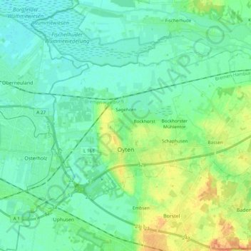
Name: Oyten topographic map, elevation, terrain.
Location: Oyten, Landkreis Verden, Lower Saxony, 28876, Germany (53.03608 8.96112 53.10453 9.15111)
Average elevation: 36 ft
Minimum elevation: 0 ft
Maximum elevation: 125 ft
Thank you for supporting this site ❤️
Make a donation
Make a donation
Gear up for your next adventure:
As an Amazon Associate, this site earns from qualifying purchases at no extra cost to you.
Other topographic maps
Click on a map to view its topography, its elevation and its terrain.
Klein Eissel
Germany > Lower Saxony > Landkreis Verden > Verden (Aller) > Eissel bei Verden
Average elevation: 36 ft