
Make a donation
Gear up for your next adventure:
As an Amazon Associate, this site earns from qualifying purchases at no extra cost to you.
Pully topographic map
Click on the map to display elevation.
Make a donation
Gear up for your next adventure:
As an Amazon Associate, this site earns from qualifying purchases at no extra cost to you.
Pully
The municipality stretches from Lake Geneva to the Jorat and includes the peak of Monts-de-Pully at an elevation of 806 m (2,644 ft). It consists of the village section of Chamblandes, La Perraudettaz, Port, Rochettaz and La Rosiaz.
Make a donation
Gear up for your next adventure:
As an Amazon Associate, this site earns from qualifying purchases at no extra cost to you.
About this map
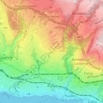
Name: Pully topographic map, elevation, terrain.
Location: Pully, District de Lavaux-Oron, Vaud, Switzerland (46.50392 6.63934 46.54464 6.70218)
Average elevation: 1,896 ft
Minimum elevation: 1,211 ft
Maximum elevation: 2,684 ft
Make a donation
Gear up for your next adventure:
As an Amazon Associate, this site earns from qualifying purchases at no extra cost to you.