
Make a donation
Gear up for your next adventure:
As an Amazon Associate, this site earns from qualifying purchases at no extra cost to you.
Monroe County topographic map
Click on the map to display elevation.
Make a donation
Gear up for your next adventure:
As an Amazon Associate, this site earns from qualifying purchases at no extra cost to you.
Monroe County
According to the Trewartha climate classification system, the higher elevation Pocono Plateau Region of Monroe County has a Temperate Continental climate (Dc) with warm summers (b), cold winters (o) and year-around precipitation (Dcbo). Dcbo climates are characterized by at least one month having an average mean temperature ≤ 32.0 °F (0.0 °C), four to seven months with an average mean temperature ≥ 50.0 °F (10.0 °C), all months with an average mean temperature < 72.0 °F (22.2 °C) and no significant precipitation difference between seasons. Although most summer days are comfortably humid on the Pocono Plateau, episodes of heat and high humidity can occur with heat index values > 92 °F (33 °C). Since 1981, the highest air temperature was 93.0 °F (33.9 °C) on 07/15/1995, and the highest daily average mean dew point was 70.8 °F (21.6 °C) on 08/01/2006. July is the peak month for thunderstorm activity which correlates with the average warmest month of the year. Since 1981, the wettest calendar day was 6.43 inches (163 mm) on 09/30/2010. During the winter months, the plant hardiness zone is 5b with an average annual extreme minimum air temperature of −11.2 °F (−24.0 °C). Since 1981, the coldest air temperature was −22.9 °F (−30.5 °C) on 01/21/1994. Episodes of extreme cold and wind can occur with wind chill values < −24 °F (−31 °C). The average snowiest month is January which correlates with the average coldest month of the year. Ice storms and large snowstorms depositing ≥ 12 inches (30 cm) of snow occur nearly every year, particularly during nor’easters from December through March.
Make a donation
Gear up for your next adventure:
As an Amazon Associate, this site earns from qualifying purchases at no extra cost to you.
About this map
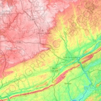
Name: Monroe County topographic map, elevation, terrain.
Location: Monroe County, Pennsylvania, United States (40.81484 -75.64929 41.25213 -74.96660)
Average elevation: 1,184 ft
Minimum elevation: 184 ft
Maximum elevation: 2,244 ft
Pennsylvania trails, hiking, mountain biking, running and outdoor activities
Make a donation
Gear up for your next adventure:
As an Amazon Associate, this site earns from qualifying purchases at no extra cost to you.
Other topographic maps
Click on a map to view its topography, its elevation and its terrain.
East Texas
United States > Pennsylvania > Lehigh County > Lower Macungie Township
Average elevation: 413 ft
Albrightsville
United States > Pennsylvania > Carbon County > Kidder Township
Average elevation: 1,634 ft
Donegal Lake
United States > Pennsylvania > Westmoreland County > Donegal Township
Average elevation: 1,617 ft
Make a donation
Gear up for your next adventure:
As an Amazon Associate, this site earns from qualifying purchases at no extra cost to you.
Orefield
United States > Pennsylvania > Lehigh County > North Whitehall Township
Average elevation: 463 ft
Dingmans Ferry
United States > Pennsylvania > Pike County > Delaware Township
Average elevation: 630 ft
Make a donation
Gear up for your next adventure:
As an Amazon Associate, this site earns from qualifying purchases at no extra cost to you.
Middlebury Center
United States > Pennsylvania > Tioga County > Middlebury Township
Average elevation: 1,516 ft
Woxall
United States > Pennsylvania > Montgomery County > Upper Salford Township
Average elevation: 322 ft
Malden Place
United States > Pennsylvania > Washington County > Centerville
Average elevation: 1,053 ft
Make a donation
Gear up for your next adventure:
As an Amazon Associate, this site earns from qualifying purchases at no extra cost to you.
Centreville
United States > Pennsylvania > Lehigh County > Lower Macungie Township
Average elevation: 472 ft
Bass Lake
United States > Pennsylvania > York County > Newberry Township > Valley Green
Average elevation: 469 ft
Croydon Heights
United States > Pennsylvania > Bucks County > Bristol Township > Croydon
Average elevation: 33 ft
Fitzwatertown
United States > Pennsylvania > Montgomery County > Upper Dublin Township
Average elevation: 282 ft
Make a donation
Gear up for your next adventure:
As an Amazon Associate, this site earns from qualifying purchases at no extra cost to you.
Starview
United States > Pennsylvania > York County > East Manchester Township
Average elevation: 509 ft
North Towanda
United States > Pennsylvania > Bradford County > North Towanda Township
Average elevation: 938 ft
Tannersville
United States > Pennsylvania > Monroe County > Pocono Township
Average elevation: 1,037 ft
Make a donation
Gear up for your next adventure:
As an Amazon Associate, this site earns from qualifying purchases at no extra cost to you.
Valley Forge
United States > Pennsylvania > Chester County > Schuylkill Township
Average elevation: 256 ft
Make a donation
Gear up for your next adventure:
As an Amazon Associate, this site earns from qualifying purchases at no extra cost to you.
Port Trevorton
United States > Pennsylvania > Snyder County > Union Township
Average elevation: 528 ft
Make a donation
Gear up for your next adventure:
As an Amazon Associate, this site earns from qualifying purchases at no extra cost to you.
Freemont
United States > Pennsylvania > Chester County > West Nottingham Township
Average elevation: 377 ft
Sturgeon
United States > Pennsylvania > Allegheny County > North Fayette Township
Average elevation: 1,096 ft
Glade Mills
United States > Pennsylvania > Butler County > Middlesex Township
Average elevation: 1,178 ft
Make a donation
Gear up for your next adventure:
As an Amazon Associate, this site earns from qualifying purchases at no extra cost to you.
Knickerbocker
United States > Pennsylvania > Chester County > Willistown Township
Average elevation: 417 ft
Carlisle Springs
United States > Pennsylvania > Cumberland County > Middlesex Township
Average elevation: 597 ft
Vance
United States > Pennsylvania > Washington County > South Strabane Township
Average elevation: 1,217 ft
Sagamore Estates
United States > Pennsylvania > Pike County > Shohola Township
Average elevation: 1,352 ft
Make a donation
Gear up for your next adventure:
As an Amazon Associate, this site earns from qualifying purchases at no extra cost to you.
Bonnie Brook
United States > Pennsylvania > Butler County > Summit Township
Average elevation: 1,204 ft
Evansburg State Park
United States > Pennsylvania > Montgomery County > Worcester Township > Cedars
Average elevation: 230 ft
Cross Fork
United States > Pennsylvania > Potter County > Stewardson Township
Average elevation: 1,532 ft
Make a donation
Gear up for your next adventure:
As an Amazon Associate, this site earns from qualifying purchases at no extra cost to you.
Ithan
United States > Pennsylvania > Delaware County > Radnor Township > Saint Davids
Average elevation: 381 ft
Drumore Center
United States > Pennsylvania > Lancaster County > Drumore Township
Average elevation: 574 ft
Make a donation
Gear up for your next adventure:
As an Amazon Associate, this site earns from qualifying purchases at no extra cost to you.
Hanover Junction
United States > Pennsylvania > York County > North Codorus Township
Average elevation: 614 ft
Stiefler Corner
United States > Pennsylvania > Bedford County > Kimmel Township
Average elevation: 1,706 ft
Make a donation
Gear up for your next adventure:
As an Amazon Associate, this site earns from qualifying purchases at no extra cost to you.
Leather Corner Post
United States > Pennsylvania > Lehigh County > Lowhill Township
Average elevation: 584 ft
Welsh Mountain Nature Preserve
United States > Pennsylvania > Lancaster County > East Earl Township
Average elevation: 965 ft
Cambra
United States > Pennsylvania > Luzerne County > Huntington Township
Average elevation: 1,020 ft
East Springfield
United States > Pennsylvania > Erie County > Springfield Township
Average elevation: 751 ft
Make a donation
Gear up for your next adventure:
As an Amazon Associate, this site earns from qualifying purchases at no extra cost to you.
Raven Rock Mountain
United States > Pennsylvania > Adams County > Liberty Township
Average elevation: 1,024 ft
Strickhousers
United States > Pennsylvania > York County > North Codorus Township
Average elevation: 673 ft
Reeds Corners
United States > Pennsylvania > Erie County > McKean Township
Average elevation: 1,352 ft
Make a donation
Gear up for your next adventure:
As an Amazon Associate, this site earns from qualifying purchases at no extra cost to you.
Greece City
United States > Pennsylvania > Butler County > Concord Township
Average elevation: 1,227 ft
Pocono Lake
United States > Pennsylvania > Monroe County > Tobyhanna Township
Average elevation: 1,781 ft
Intercourse
United States > Pennsylvania > Lancaster County > Leacock Township
Average elevation: 417 ft
Make a donation
Gear up for your next adventure:
As an Amazon Associate, this site earns from qualifying purchases at no extra cost to you.
Coolspring
United States > Pennsylvania > Jefferson County > Oliver Township
Average elevation: 1,490 ft
East Waterford
United States > Pennsylvania > Juniata County > Tuscarora Township
Average elevation: 843 ft
Make a donation
Gear up for your next adventure:
As an Amazon Associate, this site earns from qualifying purchases at no extra cost to you.
Pleasant View
United States > Pennsylvania > Centre County > Spring Township
Average elevation: 971 ft
Make a donation
Gear up for your next adventure:
As an Amazon Associate, this site earns from qualifying purchases at no extra cost to you.
Crooked Creek Lake
United States > Pennsylvania > Armstrong County > Bethel Township
Average elevation: 945 ft
East Passyunk Community Recreation Center
United States > Pennsylvania > Philadelphia County > Philadelphia
Average elevation: 30 ft
Linhart
United States > Pennsylvania > Allegheny County > Wilkins Township
Average elevation: 1,030 ft
Make a donation
Gear up for your next adventure:
As an Amazon Associate, this site earns from qualifying purchases at no extra cost to you.
Bloomington
United States > Pennsylvania > Clearfield County > Pike Township
Average elevation: 1,417 ft
Sharon Center
United States > Pennsylvania > Potter County > Sharon Township
Average elevation: 1,739 ft
Make a donation
Gear up for your next adventure:
As an Amazon Associate, this site earns from qualifying purchases at no extra cost to you.
Roaring Branch
United States > Pennsylvania > Tioga County > Union Township
Average elevation: 1,539 ft
Beechmont
United States > Pennsylvania > Allegheny County > Collier Township
Average elevation: 1,076 ft
Promised Land
United States > Pennsylvania > Pike County > Greene Township
Average elevation: 1,772 ft
Make a donation
Gear up for your next adventure:
As an Amazon Associate, this site earns from qualifying purchases at no extra cost to you.
Coraopolis Heights
United States > Pennsylvania > Allegheny County > Findlay Township
Average elevation: 1,050 ft
Smithville
United States > Pennsylvania > Lancaster County > Providence Township
Average elevation: 459 ft
Maple Grove Park
United States > Pennsylvania > Berks County > Brecknock Township
Average elevation: 650 ft
Abbot Ridge
United States > Pennsylvania > Bedford County > Liberty Township
Average elevation: 958 ft
Make a donation
Gear up for your next adventure:
As an Amazon Associate, this site earns from qualifying purchases at no extra cost to you.
Mont Clare
United States > Pennsylvania > Montgomery County > Upper Providence Township
Average elevation: 184 ft
Owl Hollow
United States > Pennsylvania > Bradford County > Windham Township
Average elevation: 1,178 ft
Make a donation
Gear up for your next adventure:
As an Amazon Associate, this site earns from qualifying purchases at no extra cost to you.
Teepleville
United States > Pennsylvania > Crawford County > Richmond Township
Average elevation: 1,266 ft
Central Highlands
United States > Pennsylvania > Allegheny County > Elizabeth Township
Average elevation: 1,073 ft
Make a donation
Gear up for your next adventure:
As an Amazon Associate, this site earns from qualifying purchases at no extra cost to you.
West Export
United States > Pennsylvania > Westmoreland County > Murrysville
Average elevation: 1,119 ft
Tyler State Park
United States > Pennsylvania > Bucks County > Northampton Township
Average elevation: 220 ft
Make a donation
Gear up for your next adventure:
As an Amazon Associate, this site earns from qualifying purchases at no extra cost to you.
Make a donation
Gear up for your next adventure:
As an Amazon Associate, this site earns from qualifying purchases at no extra cost to you.