Geolocate

Baralla topographic map

Click on the map to display elevation.

About this map
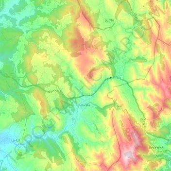
Name: Baralla topographic map, elevation, terrain.

Location: Baralla, Os Ancares, Lugo, Galicia, Spain (42.83296 -7.35078 42.99022 -7.15711)

Average elevation: 2,136 ft

Minimum elevation: 1,312 ft

Maximum elevation: 3,839 ft

Other topographic maps

Click on a map to view its topography, its elevation and its terrain.
Ferreiras

Spain > Galicia > Os Ancares > As Nogais

Average elevation: 3,363 ft

Gear up for your next adventure:

❄️Traction Cleats - Prevent slips on icy trails during winter hikes
🚗GPS Dash Cams - Record your scenic drives through mountain passes and canyons
🌧️Backpack Rain Cover - Keep gear dry in wet weather
🦺Reflective Outdoor Gear - Safety gear for low‑light conditions
🦟Ultrasonic Repellers - Create a bug-free zone at your camp or rest stop

As an Amazon Associate, this site earns from qualifying purchases at no extra cost to you.