
Pico Island topographic map
Interactive map
Click on the map to display elevation.
About this map
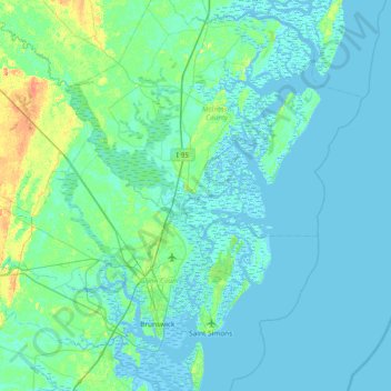
Name: Pico Island topographic map, elevation, terrain.
Location: Pico Island, McIntosh County, Georgia, 31305, USA (31.03995 -81.73760 31.67995 -81.09760)
Average elevation: 13 ft
Minimum elevation: -16 ft
Maximum elevation: 105 ft
Other topographic maps
Click on a map to view its topography, its elevation and its terrain.
Lake Oconee
USA > Georgia > Lake Oconee
Lake Oconee, Greene County, Georgia, USA
Average elevation: 495 ft
Tybee Island
USA > Georgia > Tybee Island
Tybee Island, Chatham County, Georgia, 31328, USA
Average elevation: 7 ft
Lake Sinclair
USA > Georgia > Crooked Creek
Lake Sinclair, Clubhouse Road, Crooked Creek, Putnam County, Georgia, 31024, USA
Average elevation: 456 ft
Lake Seminole
USA > Georgia > Paradise Acres
Lake Seminole, Paradise Acres, Seminole County, Georgia, USA
Average elevation: 105 ft
Hutchinson Island
Hutchinson Island, Chatham County, Georgia, 31421, USA
Average elevation: 23 ft
Lake Spivey
Lake Spivey, South Bay Drive, Lake Jodeco, Clayton County, Georgia, 30236, USA
Average elevation: 827 ft
Allatoona Lake
Allatoona Lake, Macedonia Road, Corbin, Bartow County, Georgia, 30184, USA
Average elevation: 902 ft
Lake Rabun
Lake Rabun, Banks Lane, Lakemont, Rabun County, Georgia, 30552, USA
Average elevation: 1,991 ft
White Oak Lake
White Oak Lake, Austin Lake Circle Southeast, Smyrna Heights, Smyrna, Cobb County, Georgia, 30082, USA
Average elevation: 1,001 ft
Mount Oglethorpe
Mount Oglethorpe, Pickens County, Georgia, USA
Average elevation: 2,480 ft
Phinizy Swamp Nature Park
Phinizy Swamp Nature Park, Augusta, Richmond County, Georgia, USA
Average elevation: 121 ft
Washington
USA > Georgia > Washington
Washington, Wilkes County, Georgia, USA
Average elevation: 561 ft
Charlie Elliott Wildlife Center
Charlie Elliott Wildlife Center, abandoned track, Prospect, Jasper County, Georgia, 30055, USA
Average elevation: 676 ft
Brook Run Park
Brook Run Park, Shenandoah, Dunwoody, DeKalb County, Georgia, USA
Average elevation: 1,001 ft
Highland Oaks
USA > Georgia > Highland Oaks
Highland Oaks, Camden County, Georgia, USA
Average elevation: 7 ft
Adams Crossroads
USA > Georgia > Adams Crossroads
Adams Crossroads, Gwinnett County, Georgia, 30096-4590, USA
Average elevation: 984 ft
Coxs Crossing
USA > Georgia > Coxs Crossing
Coxs Crossing, Clayton County, Georgia, 30304, USA
Average elevation: 942 ft
State College
USA > Georgia > State College
State College, Peach County, Georgia, 31030, USA
Average elevation: 505 ft
Norris Lake
Norris Lake, Lake Drive Southwest, Norris Lake Shores, Caleb, Gwinnett County, Georgia, 30039, USA
Average elevation: 820 ft
Horsetrough Mountain
Horsetrough Mountain, Union County, Georgia, USA
Average elevation: 3,189 ft
Kings Pond
USA > Georgia > Sandersville
Kings Pond, Kaolin Road, Sandersville Operation, Sandersville, Washington County, Georgia, 31089, USA
Average elevation: 423 ft
Double Spring Knob
Double Spring Knob, Rabun County, Georgia, USA
Average elevation: 3,415 ft
Little Kennesaw Mountain
Little Kennesaw Mountain, Cobb County, Georgia, 30064, USA
Average elevation: 1,155 ft
Reynolds Nature Preserve
Reynolds Nature Preserve, Beverly Hills, Conley, Clayton County, Georgia, 30260-1250, USA
Average elevation: 955 ft
Saddle Mountain
Saddle Mountain, Rome, Floyd County, Georgia, 30161, USA
Average elevation: 741 ft
Okefenokee Wilderness
Okefenokee Wilderness, Charlton County, Georgia, USA
Average elevation: 112 ft
Jarrell Plantation State Historic Site
Jarrell Plantation State Historic Site, Jones County, Georgia, 31086, USA
Average elevation: 427 ft
Chattahoochee Nature Center
Chattahoochee Nature Center, North Point, Roswell, Fulton County, Georgia, USA
Average elevation: 948 ft
Buford Horizons Mobile Home Park
USA > Georgia > Buford Horizons Mobile Home Park
Buford Horizons Mobile Home Park, Gwinnett County, Georgia, 30158, USA
Average elevation: 1,076 ft
Blood Mountain Wilderness
Blood Mountain Wilderness, abandoned road, Lumpkin County, Georgia, USA
Average elevation: 2,805 ft
Birdsong Nature Center
USA > Georgia > Rocky Hill
Birdsong Nature Center, Meridian Road, Rocky Hill, Grady County, Georgia, USA
Average elevation: 220 ft
Cherokee Lake
USA > Georgia > Thomasville
Cherokee Lake, Thomasville, Thomas County, Georgia, USA
Average elevation: 282 ft
Highland Mills
USA > Georgia > Highland Mills
Highland Mills, Spalding County, Georgia, 30223, USA
Average elevation: 896 ft
Tallulah Falls Lake
USA > Georgia > Tallulah Falls
Tallulah Falls Lake, Terrora Circle, Tallulah Falls, Rabun County, Georgia, 30573, USA
Average elevation: 1,798 ft
Levelland Mountain
Levelland Mountain, Union County, Georgia, USA
Average elevation: 3,031 ft
Harris Neck National Wildlife Refuge
USA > Georgia > Thomas Landing
Harris Neck National Wildlife Refuge, Thomas Landing, McIntosh County, Georgia, USA
Average elevation: 10 ft
Cohutta Springs
USA > Georgia > Cohutta Springs
Cohutta Springs, Murray County, Georgia, 30711, USA
Average elevation: 1,030 ft
Cameron Point
USA > Georgia > Cameron Point
Cameron Point, Hall County, Georgia, 30506:30534, USA
Average elevation: 1,112 ft
Sandy Creek Nature Center
Sandy Creek Nature Center, 205, Athens, Athens-Clarke County, Georgia, 30607, USA
Average elevation: 659 ft
Screamer Mountain
Screamer Mountain, Rabun County, Georgia, 03056, USA
Average elevation: 2,139 ft