
Corrado Corners topographic map
Interactive map
Click on the map to display elevation.
About this map
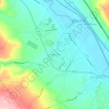
Name: Corrado Corners topographic map, elevation, terrain.
Average elevation: 558 ft
Minimum elevation: 371 ft
Maximum elevation: 1,066 ft
Other topographic maps
Click on a map to view its topography, its elevation and its terrain.
East Frankfort
United States > New York > Herkimer County > Town of Frankfort
East Frankfort, Town of Frankfort, Herkimer County, New York, United States
Average elevation: 499 ft
Harbor
United States > New York > Herkimer County > Town of Frankfort
Harbor, Town of Frankfort, Herkimer County, New York, 13504, United States
Average elevation: 512 ft
Frankfort Center
United States > New York > Herkimer County > Town of Frankfort
Frankfort Center, Town of Frankfort, Herkimer County, New York, 13340, United States
Average elevation: 945 ft
West Frankfort
United States > New York > Herkimer County > Town of Frankfort
West Frankfort, Town of Frankfort, Herkimer County, New York, 13504, United States
Average elevation: 472 ft
Stewart Corners
United States > New York > Herkimer County > Town of Frankfort
Stewart Corners, Town of Frankfort, Herkimer County, New York, United States
Average elevation: 1,286 ft
Gulph
United States > New York > Herkimer County > Town of Frankfort
Gulph, Town of Frankfort, Herkimer County, New York, United States
Average elevation: 1,273 ft