
Γρεβενά topographic map
Interactive map
Click on the map to display elevation.
About this map
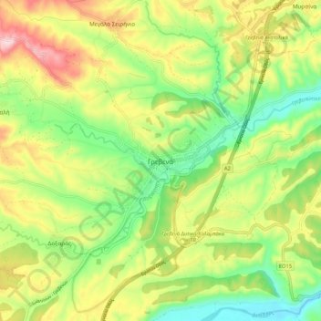
Name: Γρεβενά topographic map, elevation, terrain.
Average elevation: 1,913 ft
Minimum elevation: 1,522 ft
Maximum elevation: 2,444 ft
Die Einwohner leben von Landwirtschaft, Tierhaltung und Handwerk. Die Nutztierhaltung findet dabei in relativ großen Höhen von 1000 bis 1500 m statt, wo die Herden der Nutztiere bisweilen auch überwintern. Im Tal des Greveniotis wird Weizen, Gerste und andere Futtermittel angebaut.
Other topographic maps
Click on a map to view its topography, its elevation and its terrain.
Δεσκάτη
Griechenland > Epirus - Westmakedonien > Regionalbezirk Grevena
Δεσκάτη, Δήμος Δεσκάτης, Regionalbezirk Grevena, Region Westmakedonien, Epirus - Westmakedonien, 512 00, Griechenland
Average elevation: 3,123 ft