
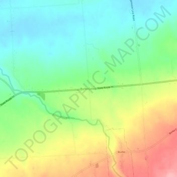
Burke Center topographic map
Interactive map
Click on the map to display elevation.
About this map
Name: Burke Center topographic map, elevation, terrain.
Average elevation: 712 ft
Minimum elevation: 558 ft
Maximum elevation: 958 ft
Other topographic maps
Click on a map to view its topography, its elevation and its terrain.
Town of Westville
United States > New York > Franklin County
Town of Westville, Franklin County, New York, United States
Average elevation: 259 ft
Town of Moira
United States > New York > Franklin County
Town of Moira, Franklin County, New York, United States
Average elevation: 410 ft
Village of Tupper Lake
United States > New York > Franklin County
Village of Tupper Lake, Town of Tupper Lake, Franklin County, New York, 12986, United States
Average elevation: 1,588 ft
Hogansburg
United States > New York > Franklin County > Town of Bombay
Hogansburg, Town of Bombay, Franklin County, New York, 13655, United States
Average elevation: 180 ft
Fish Creek Pond Campground
United States > New York > Franklin County > Town of Santa Clara
Fish Creek Pond Campground, Town of Santa Clara, Franklin County, New York, United States
Average elevation: 1,601 ft
Town of Chateaugay
United States > New York > Franklin County > Town of Chateaugay
Town of Chateaugay, Franklin County, New York, 12920, United States
Average elevation: 919 ft
Owls Head
United States > New York > Franklin County
Owls Head, Town of Bellmont, Franklin County, New York, 12969, United States
Average elevation: 1,818 ft
Paul Smiths
United States > New York > Franklin County > Paul Smiths
Paul Smiths, Brighton, Franklin County, New York, 12970, United States
Average elevation: 1,667 ft
Moira
United States > New York > Franklin County > Moira
Moira, Franklin County, New York, 12957, United States
Average elevation: 410 ft