
Make a donation
Gear up for your next adventure:
As an Amazon Associate, this site earns from qualifying purchases at no extra cost to you.
Coon Rapids topographic map
Click on the map to display elevation.
Make a donation
Gear up for your next adventure:
As an Amazon Associate, this site earns from qualifying purchases at no extra cost to you.
About this map
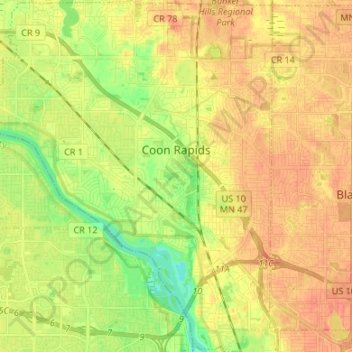
Name: Coon Rapids topographic map, elevation, terrain.
Location: Coon Rapids, Anoka County, Minnesota, United States (45.11871 -93.37356 45.21292 -93.26573)
Average elevation: 879 ft
Minimum elevation: 804 ft
Maximum elevation: 928 ft
Anoka County trails, hiking, mountain biking, running and outdoor activities
Make a donation
Gear up for your next adventure:
As an Amazon Associate, this site earns from qualifying purchases at no extra cost to you.
Other topographic maps
Click on a map to view its topography, its elevation and its terrain.
Rum River North County Park
United States > Minnesota > Anoka County > Saint Francis
Average elevation: 915 ft
Make a donation
Gear up for your next adventure:
As an Amazon Associate, this site earns from qualifying purchases at no extra cost to you.