
Theodore Roosevelt National Park topographic map
Interactive map
Click on the map to display elevation.
About this map
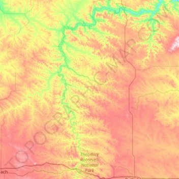
Name: Theodore Roosevelt National Park topographic map, elevation, terrain.
Average elevation: 2,480 ft
Minimum elevation: 1,880 ft
Maximum elevation: 3,281 ft
The wilderness protects from development the wildest sections of the National Park, an area described as badlands where erosional forces have carved steep cliffs into the relatively flat prairie. Bison, pronghorn, elk, mule deer and coyote are all found here, along with hundreds of species of birds such as the bald eagle, falcon and hawk. The wilderness is separated into two sections along with the park, a north and a south unit, by a distance of 70 miles (110 km). The Little Missouri River is on the south side of both units and is credited for being the primary erosional source which created the badlands topography.
Other topographic maps
Click on a map to view its topography, its elevation and its terrain.
Medora
United States > North Dakota > Billings County
Medora, Billings County, North Dakota, 58645, United States
Average elevation: 2,362 ft