Geolocate

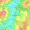
Breuna topographic map

Click on the map to display elevation.

About this map

Name: Breuna topographic map, elevation, terrain.

Location: Breuna, Landkreis Kassel, Hesse, 34479, Germany (51.39682 9.13971 51.47200 9.27724)

Average elevation: 899 ft

Minimum elevation: 531 ft

Maximum elevation: 1,427 ft

Other topographic maps

Click on a map to view its topography, its elevation and its terrain.
Trendelburg

Germany > Hesse > Landkreis Kassel

Average elevation: 653 ft

Hirschköpfchen

Germany > Hesse > Landkreis Kassel

Average elevation: 968 ft

Gear up for your next adventure:

🦟Ultrasonic Repellers - Create a bug-free zone at your camp or rest stop
🏥Hiking First Aid Kits - Comprehensive medical kits for remote trail injuries
🧢Sun Protection Hats - Wide-brimmed and UPF-rated hats for high-altitude sun safety
🪶Paracord Bracelet - Survival bracelet with built‑in tools
🛡️Bear Spray Outdoor - Protection in bear country hikes

As an Amazon Associate, this site earns from qualifying purchases at no extra cost to you.