
Col Agnel / Colle dell'Agnello topographic map
Interactive map
Click on the map to display elevation.
About this map
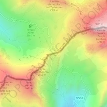
Name: Col Agnel / Colle dell'Agnello topographic map, elevation, terrain.
Average elevation: 8,858 ft
Minimum elevation: 7,477 ft
Maximum elevation: 10,384 ft
Other topographic maps
Click on a map to view its topography, its elevation and its terrain.
Monviso
Italy > Piedmont > Cuneo > Pontechianale
Monviso, Pontechianale, Cuneo, Piedmont, Italy
Average elevation: 9,793 ft