
Thaakath topographic map
Interactive map
Click on the map to display elevation.
About this map
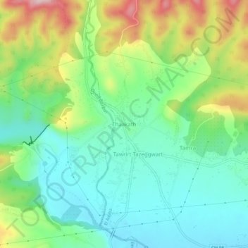
Name: Thaakath topographic map, elevation, terrain.
Location: Thaakath, El Adjiba, Daïra Bechloul, Bouira, 10087, Algérie (36.34049 4.09924 36.38049 4.13924)
Average elevation: 1,532 ft
Minimum elevation: 1,247 ft
Maximum elevation: 2,110 ft
Other topographic maps
Click on a map to view its topography, its elevation and its terrain.
Amalou
Algérie > Bouira > Daïra Bechloul > El Adjiba
Amalou, El Adjiba, Daïra Bechloul, Bouira, 10087, Algérie
Average elevation: 1,453 ft