
Edmore topographic map
Interactive map
Click on the map to display elevation.
About this map
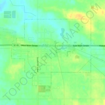
Name: Edmore topographic map, elevation, terrain.
Average elevation: 974 ft
Minimum elevation: 935 ft
Maximum elevation: 1,017 ft
Other topographic maps
Click on a map to view its topography, its elevation and its terrain.
Carson City
United States > Michigan > Montcalm County
Carson City, Montcalm County, Michigan, 48811, United States
Average elevation: 761 ft
Fairplain Township
United States > Michigan > Montcalm County
Fairplain Township, Montcalm County, Michigan, United States
Average elevation: 843 ft
Stanton
United States > Michigan > Montcalm County
Stanton, Montcalm County, Michigan, United States
Average elevation: 922 ft
Belvidere Township
United States > Michigan > Montcalm County
Belvidere Township, Montcalm County, Michigan, 48886, United States
Average elevation: 951 ft
Douglass Township
United States > Michigan > Montcalm County
Douglass Township, Montcalm County, Michigan, 48888, United States
Average elevation: 928 ft
Crystal Township
United States > Michigan > Montcalm County
Crystal Township, Montcalm County, Michigan, 48818, United States
Average elevation: 791 ft
Edmore
United States > Michigan > Montcalm County > Edmore
Edmore, Home Township, Montcalm County, Michigan, 48829, United States
Average elevation: 971 ft