
Desert National Park (Thar) topographic map
Interactive map
Click on the map to display elevation.
About this map
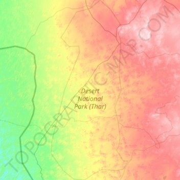
Name: Desert National Park (Thar) topographic map, elevation, terrain.
Average elevation: 538 ft
Minimum elevation: 128 ft
Maximum elevation: 1,148 ft
Other topographic maps
Click on a map to view its topography, its elevation and its terrain.
Lakha
India > Rajasthan > Fatehgarh Tehsil
Lakha, Fatehgarh Tehsil, Jaisalmer District, Rajasthan, India
Average elevation: 892 ft
Megha
India > Rajasthan > Fatehgarh Tehsil
Megha, Fatehgarh Tehsil, Jaisalmer District, Rajasthan, India
Average elevation: 879 ft
Bhopa
India > Rajasthan > Fatehgarh Tehsil > Bhopa
Bhopa, Fatehgarh Tehsil, Jaisalmer, Rajasthan, India
Average elevation: 892 ft