
Ighil Igoulmimene topographic map
Interactive map
Click on the map to display elevation.
About this map
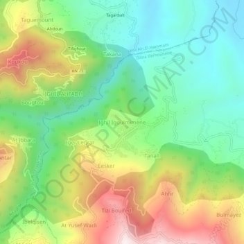
Name: Ighil Igoulmimene topographic map, elevation, terrain.
Average elevation: 1,962 ft
Minimum elevation: 902 ft
Maximum elevation: 3,681 ft
Other topographic maps
Click on a map to view its topography, its elevation and its terrain.
Imsouhal
Algérie > Tizi Ouzou > Daïra Iferhounene > Imsouhal
Imsouhal, Daïra Iferhounene, Tizi Ouzou, 15024, Algérie
Average elevation: 2,169 ft
Esker
Algérie > Tizi Ouzou > Daïra Iferhounene > Imsouhal
Esker, Imsouhal, Daïra Iferhounene, Tizi Ouzou, 15024, Algérie
Average elevation: 2,300 ft