
Redfield topographic map
Interactive map
Click on the map to display elevation.
About this map
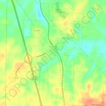
Name: Redfield topographic map, elevation, terrain.
Location: Redfield, Jefferson County, Arkansas, 72132, United States (34.41955 -92.19995 34.46484 -92.16449)
Average elevation: 312 ft
Minimum elevation: 236 ft
Maximum elevation: 384 ft
Other topographic maps
Click on a map to view its topography, its elevation and its terrain.
White Hall
United States > Arkansas > Jefferson County
White Hall, Jefferson County, Arkansas, 71602, United States
Average elevation: 266 ft
Pine Bluff
United States > Arkansas > Jefferson County
Pine Bluff, Jefferson County, Arkansas, United States
Average elevation: 226 ft
Pine Bluff
United States > Arkansas > Jefferson County > Pine Bluff > Pine Bluff
Pine Bluff, Jefferson County, Arkansas, 71601, United States
Average elevation: 240 ft