Geolocate

Veterans Administration topographic map

Click on the map to display elevation.

About this map

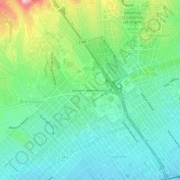
Name: Veterans Administration topographic map, elevation, terrain.

Location: Veterans Administration, California, 90073, United States (34.03464 -118.47831 34.07464 -118.43831)

Average elevation: 344 ft

Minimum elevation: 167 ft

Maximum elevation: 791 ft

California trails, hiking, mountain biking, running and outdoor activities

Gear up for your next adventure:

🧦Hiking Socks - Comfortable socks to prevent blisters on long hikes
🥇GPS Hiking Watch - Multi‑sport GPS watch with navigation and trail tracking
🎒Outdoor Daypacks - Lightweight backpacks designed for carrying maps and essential gear
🔥Camping Stove - Portable stove for camping and backcountry cooking
🪑Ultralight Camp Chairs - Portable seating for resting after a long day of mapping

As an Amazon Associate, this site earns from qualifying purchases at no extra cost to you.