
Make a donation
Gear up for your next adventure:
As an Amazon Associate, this site earns from qualifying purchases at no extra cost to you.
Kriens topographic map
Click on the map to display elevation.
Make a donation
Gear up for your next adventure:
As an Amazon Associate, this site earns from qualifying purchases at no extra cost to you.
Kriens
The eastern part of Kriens (the districts near the city and near Horw) lie in a valley. From Kupferhammer the land gently rises to the west, toward Obernau (elevation difference between Kupferhammer and Obernau less than 90 m (300 ft) ).
Make a donation
Gear up for your next adventure:
As an Amazon Associate, this site earns from qualifying purchases at no extra cost to you.
About this map
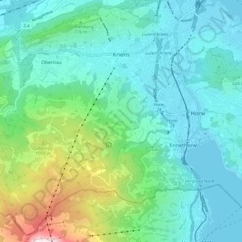
Name: Kriens topographic map, elevation, terrain.
Location: Kriens, Lucerne, Switzerland (46.98602 8.21092 47.04674 8.30526)
Average elevation: 2,313 ft
Minimum elevation: 1,398 ft
Maximum elevation: 5,787 ft
Make a donation
Gear up for your next adventure:
As an Amazon Associate, this site earns from qualifying purchases at no extra cost to you.