Geolocate

Devauden topographic map

Click on the map to display elevation.

About this map

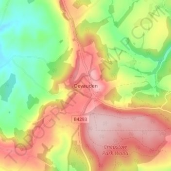
Name: Devauden topographic map, elevation, terrain.

Location: Devauden, Monmouthshire, Wales, NP16 6NB, United Kingdom (51.66847 -2.77039 51.70847 -2.73039)

Average elevation: 571 ft

Minimum elevation: 180 ft

Maximum elevation: 945 ft

Gear up for your next adventure:

🌡️Handheld Weather Meters - Measure wind, temp, and pressure for safe mountain travel
🧭Orienteering Set - Complete compass and map reading kit
🚑Emergency Bivvies - Heat-reflective sleeping bags for survival situations
🧭Map Reading Tools - Tools and kits for map navigation
👓Polarized Sunglasses - Outdoor sunglasses for glare reduction

As an Amazon Associate, this site earns from qualifying purchases at no extra cost to you.