

Teresina topographic map
Click on the map to display elevation.
Teresina
Teresina is located on the east side of the Parnaíba river at the border with Maranhão state, at an altitude of about 72 meters. The city faces the city of Timon across the river and is situated between the Parnaíba river and its tributary the Poti River. The two rivers join at the city's northern end, where there is an environmental park with gazebos. Teresina is the largest capital in the northeastern territorial extension, at 1,756 km2.
About this map
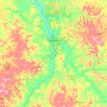
Name: Teresina topographic map, elevation, terrain.
Average elevation: 440 ft
Minimum elevation: 141 ft
Maximum elevation: 945 ft
Other topographic maps
Click on a map to view its topography, its elevation and its terrain.
Beco da Raposa
Brazil > Piauí > Região Integrada de Desenvolvimento da Grande Teresina > Teresina
Average elevation: 469 ft