Geolocate

Bongao topographic map

Click on the map to display elevation.

About this map

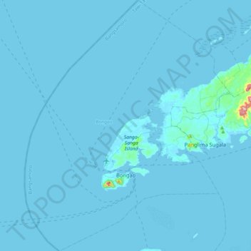
Name: Bongao topographic map, elevation, terrain.

Location: Bongao, Tawi-Tawi, Bangsamoro, 7500, Philippines (4.92115 119.62716 5.27668 119.91971)

Average elevation: 13 ft

Minimum elevation: -3 ft

Maximum elevation: 1,073 ft

Other topographic maps

Click on a map to view its topography, its elevation and its terrain.

Imam Hadji Mohammad

Philippines > Tawi-Tawi > Sibutu

Average elevation: 7 ft

Simunul, Tawi-Tawi

Philippines > Tawi-Tawi > Simunul

Average elevation: 7 ft

Laud

Philippines > Tawi-Tawi

Average elevation: 7 ft

Gear up for your next adventure:

😴Insulated Sleeping Pads - Compact and warm pads for high-elevation camping
🪶Compact Camp Shovel - Folding shovel for campsite tasks
❄️Traction Cleats - Prevent slips on icy trails during winter hikes
🚁Photography Drones - Capture stunning aerial views of landforms and topography
🎒Hydration Pack - Hands‑free water reservoir for long hikes

As an Amazon Associate, this site earns from qualifying purchases at no extra cost to you.