
五岳寨风景区 topographic map
Interactive map
Click on the map to display elevation.
About this map
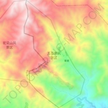
Name: 五岳寨风景区 topographic map, elevation, terrain.
Location: 五岳寨风景区, S201, 南营乡, 灵寿县, 石家庄市, 河北省, 中国 (38.68465 113.82913 38.74910 113.87561)
Average elevation: 4,751 ft
Minimum elevation: 2,270 ft
Maximum elevation: 7,001 ft