
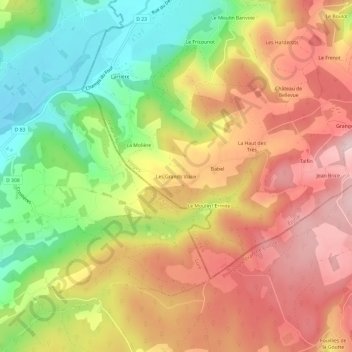
Les Grands Viaux topographic map
Interactive map
Click on the map to display elevation.
About this map
Name: Les Grands Viaux topographic map, elevation, terrain.
Average elevation: 1,604 ft
Minimum elevation: 1,050 ft
Maximum elevation: 2,093 ft
Other topographic maps
Click on a map to view its topography, its elevation and its terrain.
Faymont
France > Grand Est > Vosges > Le Val-d'Ajol
Faymont, Le Val-d'Ajol, Épinal, Vosges, Grand Est, France métropolitaine, 88340, France
Average elevation: 1,749 ft
Les Gérard
France > Grand Est > Vosges > Le Val-d'Ajol
Les Gérard, Le Val-d'Ajol, Épinal, Vosges, Grand Est, France métropolitaine, 88340, France
Average elevation: 1,854 ft
Hôtel Enfoncé
France > Grand Est > Vosges > Le Val-d'Ajol
Hôtel Enfoncé, Le Val-d'Ajol, Épinal, Vosges, Grand Est, France métropolitaine, 88340, France
Average elevation: 1,683 ft
Pcholmey
France > Grand Est > Vosges > Le Val-d'Ajol
Pcholmey, Le Val-d'Ajol, Épinal, Vosges, Grand Est, France métropolitaine, 88340, France
Average elevation: 1,709 ft
La Croisette
France > Grand Est > Vosges > Le Val-d'Ajol
La Croisette, Le Val-d'Ajol, Épinal, Vosges, Grand Est, France métropolitaine, 88340, France
Average elevation: 1,654 ft