
La Ville topographic map
Interactive map
Click on the map to display elevation.
About this map
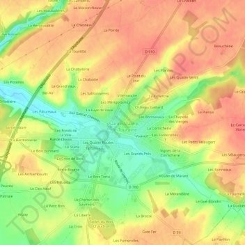
Name: La Ville topographic map, elevation, terrain.
Average elevation: 318 ft
Minimum elevation: 200 ft
Maximum elevation: 390 ft
Other topographic maps
Click on a map to view its topography, its elevation and its terrain.
Château
France > Centre-Val de Loire > Indre-et-Loire > Sainte-Maure-de-Touraine > La Ville
Château, Rue du Château, La Ville, Sainte-Maure-de-Touraine, Chinon, Indre-et-Loire, Centre-Val de Loire, France métropolitaine, 37800, France
Average elevation: 302 ft