
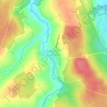
Oncourt topographic map
Interactive map
Click on the map to display elevation.
About this map
Name: Oncourt topographic map, elevation, terrain.
Average elevation: 1,138 ft
Minimum elevation: 1,010 ft
Maximum elevation: 1,253 ft
Other topographic maps
Click on a map to view its topography, its elevation and its terrain.
88150
France > Grand Est > Vosges > Thaon-les-Vosges
88150, Thaon-les-Vosges, Épinal, Vosges, Grand Est, France métropolitaine, France
Average elevation: 1,024 ft
Thaon-les-Vosges
France > Grand Est > Vosges > Thaon-les-Vosges
Thaon-les-Vosges, Épinal, Vosges, Grand Est, France métropolitaine, 88150, France
Average elevation: 1,079 ft
Girmont
France > Grand Est > Vosges > Thaon-les-Vosges
Girmont, Thaon-les-Vosges, Épinal, Vosges, Grand Est, France métropolitaine, 88150, France
Average elevation: 1,102 ft