
Cabeço dos Pinheiros topographic map
Interactive map
Click on the map to display elevation.
About this map
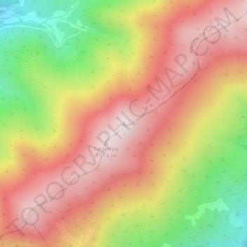
Name: Cabeço dos Pinheiros topographic map, elevation, terrain.
Location: Cabeço dos Pinheiros, Seia, Guarda, 6215-522, Portugal (40.28509 -7.64139 40.28519 -7.64129)
Average elevation: 4,003 ft
Minimum elevation: 2,690 ft
Maximum elevation: 4,964 ft
Other topographic maps
Click on a map to view its topography, its elevation and its terrain.
Lapa dos Dinheiros
Lapa dos Dinheiros, Seia, Guarda, 6270-425, Portugal
Average elevation: 2,526 ft
Serra da Estrela
Serra da Estrela, Seia, Guarda, Portugal
Average elevation: 5,988 ft
Paranhos da Beira
Paranhos da Beira, Seia, Guarda, 6270-133, Portugal
Average elevation: 1,243 ft
Aldeia da Serra
Portugal > Guarda > Seia > Aldeia da Serra
Aldeia da Serra, Seia, São Romão e Lapa dos Dinheiros, Seia, Guarda, 6270-496, Portugal
Average elevation: 2,365 ft