
Lalim topographic map
Interactive map
Click on the map to display elevation.
About this map
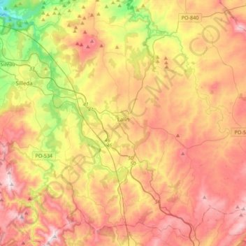
Name: Lalim topographic map, elevation, terrain.
Location: Lalim, O Deza, Pontevedra, Galiza, Espanha (42.53386 -8.26469 42.78103 -7.98823)
Average elevation: 1,955 ft
Minimum elevation: 482 ft
Maximum elevation: 3,307 ft
Other topographic maps
Click on a map to view its topography, its elevation and its terrain.
Cima do Farelo
Cima do Farelo, Ventosa, Agolada, O Deza, Pontevedra, Galiza, 27576, Espanha
Average elevation: 2,411 ft