
Oyotún topographic map
Interactive map
Click on the map to display elevation.
About this map
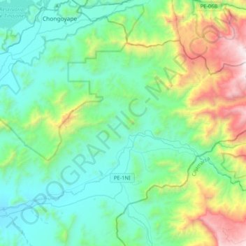
Name: Oyotún topographic map, elevation, terrain.
Location: Oyotún, Chiclayo, Lambayeque, Perú (-6.88560 -79.44063 -6.67141 -79.12085)
Average elevation: 2,211 ft
Minimum elevation: 341 ft
Maximum elevation: 8,609 ft
Other topographic maps
Click on a map to view its topography, its elevation and its terrain.
Chiclayo
Perú > Lambayeque > Chiclayo
Chiclayo, Provincia de Chiclayo, Lambayeque, Perú
Average elevation: 92 ft
Provincia de Chiclayo
Perú > Lambayeque > Pucalá
Provincia de Chiclayo, Pucalá, Chiclayo, Lambayeque, Perú
Average elevation: 1,142 ft