
Le Poirier topographic map
Interactive map
Click on the map to display elevation.
About this map
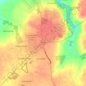
Name: Le Poirier topographic map, elevation, terrain.
Average elevation: 276 ft
Minimum elevation: 135 ft
Maximum elevation: 344 ft
Other topographic maps
Click on a map to view its topography, its elevation and its terrain.
Le Crapont
France > Bretagne > Côtes-d'Armor > Saint-Alban > Le Crapont
Le Crapont, Saint-Alban, Saint-Brieuc, Côtes-d'Armor, Bretagne, France métropolitaine, 22400, France
Average elevation: 279 ft