
Make a donation
Gear up for your next adventure:
As an Amazon Associate, this site earns from qualifying purchases at no extra cost to you.
Camp Hill topographic map
Click on the map to display elevation.
Make a donation
Gear up for your next adventure:
As an Amazon Associate, this site earns from qualifying purchases at no extra cost to you.
About this map
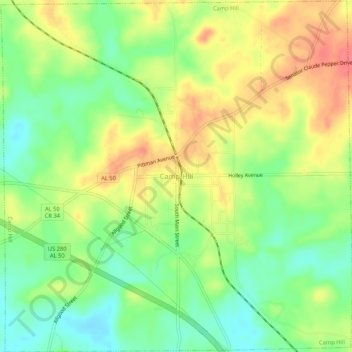
Name: Camp Hill topographic map, elevation, terrain.
Location: Camp Hill, Tallapoosa County, Alabama, 36850, United States (32.77815 -85.67984 32.82234 -85.62750)
Average elevation: 666 ft
Minimum elevation: 564 ft
Maximum elevation: 778 ft
Tallapoosa County trails, hiking, mountain biking, running and outdoor activities
Make a donation
Gear up for your next adventure:
As an Amazon Associate, this site earns from qualifying purchases at no extra cost to you.
Other topographic maps
Click on a map to view its topography, its elevation and its terrain.
Make a donation
Gear up for your next adventure:
As an Amazon Associate, this site earns from qualifying purchases at no extra cost to you.
Camp Hill
United States > Alabama > Tallapoosa County > Camp Hill > Camp Hill
Average elevation: 666 ft