
Sirtori topographic map
Interactive map
Click on the map to display elevation.
About this map
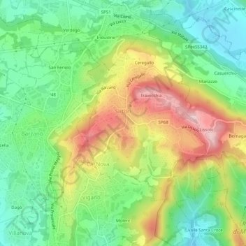
Name: Sirtori topographic map, elevation, terrain.
Location: Sirtori, Lecco, Lombardei, Italien (45.71791 9.32159 45.75194 9.35022)
Average elevation: 1,289 ft
Minimum elevation: 978 ft
Maximum elevation: 1,759 ft
Other topographic maps
Click on a map to view its topography, its elevation and its terrain.
Moregge
Italien > Lombardei > Lecco > Mandello del Lario
Moregge, Mandello del Lario, Lecco, Lombardei, 23868, Italien
Average elevation: 1,739 ft
Costa Masnaga
Costa Masnaga, Lecco, Lombardei, 23845, Italien
Average elevation: 938 ft