Geolocate

Laredo topographic map

Click on the map to display elevation.

About this map

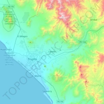
Name: Laredo topographic map, elevation, terrain.

Location: Laredo, Province of Trujillo, La Libertad, Peru (-8.20955 -79.00091 -7.96745 -78.63763)

Average elevation: 1,388 ft

Minimum elevation: -3 ft

Maximum elevation: 7,083 ft

Gear up for your next adventure:

🔦Powerful Headlamps - Ultra-bright hands-free lighting for night navigation
📱Heavy-Duty Phone Cases - Drop-proof and waterproof protection for outdoor navigation
🌡️Handheld Weather Meters - Measure wind, temp, and pressure for safe mountain travel
🚑Emergency Bivvies - Heat-reflective sleeping bags for survival situations
🔥Camping Stove - Portable stove for camping and backcountry cooking

As an Amazon Associate, this site earns from qualifying purchases at no extra cost to you.