
Gemeinde Mödling topographic map
Interactive map
Click on the map to display elevation.
About this map
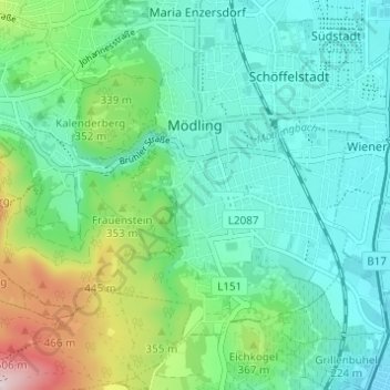
Name: Gemeinde Mödling topographic map, elevation, terrain.
Location: Gemeinde Mödling, Bezirk Mödling, Lower Austria, 2340, Austria (48.06242 16.24814 48.09397 16.30932)
Average elevation: 925 ft
Minimum elevation: 600 ft
Maximum elevation: 1,939 ft
Other topographic maps
Click on a map to view its topography, its elevation and its terrain.
Gemeinde Wiener Neudorf
Austria > Lower Austria > Bezirk Mödling
Gemeinde Wiener Neudorf, Bezirk Mödling, Lower Austria, Austria
Average elevation: 659 ft