
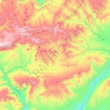
Ait Sedrate Jbel El Oulia topographic map
Interactive map
Click on the map to display elevation.
About this map
Name: Ait Sedrate Jbel El Oulia topographic map, elevation, terrain.
Average elevation: 8,435 ft
Minimum elevation: 5,420 ft
Maximum elevation: 11,870 ft
Other topographic maps
Click on a map to view its topography, its elevation and its terrain.
Ait Sedrate Jbel El Soufla
Maroc > cercle de Boulmane-Dadès
Ait Sedrate Jbel El Soufla, caïdat d'Aït Sedrate Jbel, Cercle de Boulmane-Dadès, Province de Tinghir, Drâa-Tafilalet, 45159, Maroc
Average elevation: 6,919 ft
Ait Ishaq
Maroc > cercle de Boulmane-Dadès
Ait Ishaq, Ait Youl, caïdat d'Aït Sedrate Jbel, cercle de Boulmane-Dadès, Province de Tinghir, Drâa-Tafilalet, 45159, Maroc
Average elevation: 5,568 ft