
Badoda topographic map
Interactive map
Click on the map to display elevation.
About this map
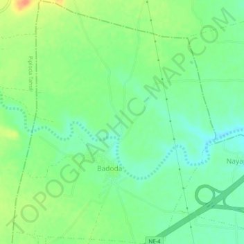
Name: Badoda topographic map, elevation, terrain.
Location: Badoda, Ratlam Tahsil, Ratlam District, Madhya Pradesh, India (23.51170 75.02940 23.54723 75.06165)
Average elevation: 1,598 ft
Minimum elevation: 1,545 ft
Maximum elevation: 1,677 ft
Other topographic maps
Click on a map to view its topography, its elevation and its terrain.
Birmawal
India > Madhya Pradesh > Ratlam Tahsil
Birmawal, Ratlam Tahsil, Ratlam District, Madhya Pradesh, India
Average elevation: 1,526 ft