
Zasenbeck topographic map
Interactive map
Click on the map to display elevation.
About this map
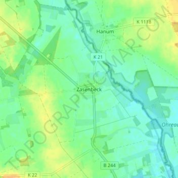
Name: Zasenbeck topographic map, elevation, terrain.
Location: Zasenbeck, Wittingen, Gifhorn, Niedersachsen, Deutschland (52.65262 10.83083 52.69262 10.87083)
Average elevation: 269 ft
Minimum elevation: 236 ft
Maximum elevation: 318 ft
Other topographic maps
Click on a map to view its topography, its elevation and its terrain.
Erpensen
Deutschland > Niedersachsen > Gifhorn > Wittingen
Erpensen, Wittingen, Gifhorn, Niedersachsen, 29378, Deutschland
Average elevation: 269 ft
Ohrdorf
Deutschland > Niedersachsen > Gifhorn > Wittingen
Ohrdorf, Wittingen, Gifhorn, Niedersachsen, Deutschland
Average elevation: 285 ft
Boitzenhagen
Deutschland > Niedersachsen > Gifhorn > Wittingen
Boitzenhagen, Wittingen, Gifhorn, Niedersachsen, Deutschland
Average elevation: 312 ft