
Wienerbruck topographic map
Interactive map
Click on the map to display elevation.
About this map
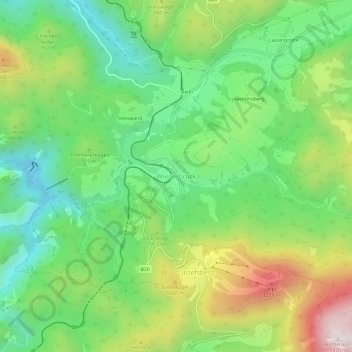
Name: Wienerbruck topographic map, elevation, terrain.
Average elevation: 2,904 ft
Minimum elevation: 2,008 ft
Maximum elevation: 4,436 ft
Other topographic maps
Click on a map to view its topography, its elevation and its terrain.
Langseitenrotte
Österreich > Niederösterreich > Bezirk Lilienfeld > Gemeinde Annaberg > Wienerbruck > Reith
Langseitenrotte, Reith, Wienerbruck, Gemeinde Annaberg, Bezirk Lilienfeld, Niederösterreich, 3223, Österreich
Average elevation: 2,782 ft