
Ridgefield topographic map
Click on the map to display elevation.
About this map
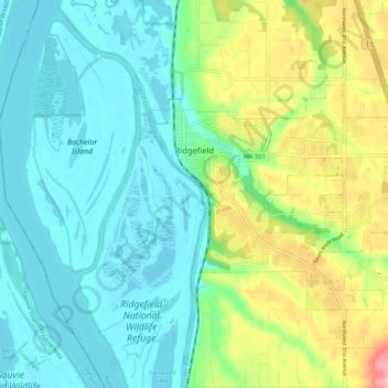
Name: Ridgefield topographic map, elevation, terrain.
Location: Ridgefield, Clark County, Washington, United States (45.78663 -122.75598 45.83028 -122.65124)
Average elevation: 125 ft
Minimum elevation: -3 ft
Maximum elevation: 446 ft
Clark County trails, hiking, mountain biking, running and outdoor activities
Other topographic maps
Click on a map to view its topography, its elevation and its terrain.
Salmon Creek Regional Park
United States > Washington > Clark County > Vancouver
Average elevation: 157 ft
Lake River
United States > Washington > Clark County > Ridgefield
Lake River, a "slow, flat slough of the Columbia River", loses only 1 foot (30 cm) in elevation over its entire 11-mile (18 km) course. It flows north, roughly parallel to the Columbia until curving slightly northwest to join it. At times, tidal fluctuations and high flows along the Columbia cause Lake River…
Average elevation: 115 ft