
Make a donation
Gear up for your next adventure:
As an Amazon Associate, this site earns from qualifying purchases at no extra cost to you.
Montague topographic map
Click on the map to display elevation.
Make a donation
Gear up for your next adventure:
As an Amazon Associate, this site earns from qualifying purchases at no extra cost to you.
About this map
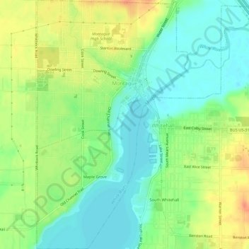
Name: Montague topographic map, elevation, terrain.
Location: Montague, Muskegon County, Michigan, United States (43.39060 -86.37604 43.42972 -86.34342)
Average elevation: 627 ft
Minimum elevation: 564 ft
Maximum elevation: 712 ft
Muskegon County trails, hiking, mountain biking, running and outdoor activities
Make a donation
Gear up for your next adventure:
As an Amazon Associate, this site earns from qualifying purchases at no extra cost to you.
Other topographic maps
Click on a map to view its topography, its elevation and its terrain.
Mona Lake Channel
United States > Michigan > Muskegon County > Norton Shores
Average elevation: 604 ft
Make a donation
Gear up for your next adventure:
As an Amazon Associate, this site earns from qualifying purchases at no extra cost to you.