
Larbaâ topographic map
Interactive map
Click on the map to display elevation.
About this map
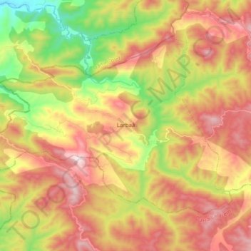
Name: Larbaâ topographic map, elevation, terrain.
Location: Larbaâ, Daïra Lazharia, Tissemsilt, Algérie (35.86798 1.38915 35.95518 1.54163)
Average elevation: 2,238 ft
Minimum elevation: 873 ft
Maximum elevation: 3,510 ft
Other topographic maps
Click on a map to view its topography, its elevation and its terrain.
Boucaïd
Algérie > Tissemsilt > Daïra Lazharia
Boucaïd, Daïra Lazharia, Tissemsilt, 38005, Algérie
Average elevation: 2,828 ft