
L'Aghja topographic map
Interactive map
Click on the map to display elevation.
About this map
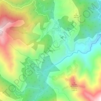
Name: L'Aghja topographic map, elevation, terrain.
Average elevation: 2,723 ft
Minimum elevation: 1,503 ft
Maximum elevation: 4,734 ft
Other topographic maps
Click on a map to view its topography, its elevation and its terrain.
Bergeries de Pezzo
France > Corse > Haute-Corse > Ghisoni
Bergeries de Pezzo, Ghisoni, Corte, Haute-Corse, Corse, France métropolitaine, 20227, France
Average elevation: 3,570 ft
Refuge d'E Capanelle
France > Corse > Haute-Corse > Ghisoni
Refuge d'E Capanelle, GR20, Capanelle, Ghisoni, Corte, Haute-Corse, Corse, France métropolitaine, 20227, France
Average elevation: 5,371 ft