
Poggio topographic map
Interactive map
Click on the map to display elevation.
About this map
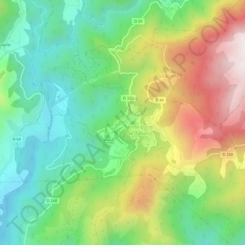
Name: Poggio topographic map, elevation, terrain.
Average elevation: 1,368 ft
Minimum elevation: 262 ft
Maximum elevation: 3,153 ft
Other topographic maps
Click on a map to view its topography, its elevation and its terrain.
Saint-André-de-Tallano
France > Corse > Corse-du-Sud > Sainte-Lucie-de-Tallano > Saint-André-de-Tallano
Saint-André-de-Tallano, Sainte-Lucie-de-Tallano, Sartène, Corse-du-Sud, Corse, France métropolitaine, 20112, France
Average elevation: 1,555 ft