
Afir topographic map
Interactive map
Click on the map to display elevation.
About this map
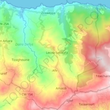
Name: Afir topographic map, elevation, terrain.
Location: Afir, Daïra Dellys, Boumerdès, Algérie (36.80728 3.94964 36.90466 4.03883)
Average elevation: 1,033 ft
Minimum elevation: 0 ft
Maximum elevation: 2,428 ft
Other topographic maps
Click on a map to view its topography, its elevation and its terrain.
Mayouya
Algérie > Boumerdès > Daïra Dellys > Dellys
Mayouya, Dellys, Daïra Dellys, Boumerdès, 35004, Algérie
Average elevation: 121 ft
Dellys
Algérie > Boumerdès > Daïra Dellys
Dellys, Daïra Dellys, Boumerdès, Algérie
Average elevation: 190 ft
Dellys
Algérie > Boumerdès > Daïra Dellys
Dellys, Daïra Dellys, Boumerdès, Algérie
Average elevation: 469 ft
Amaâdhi
Algérie > Boumerdès > Daïra Dellys > Amaâdhi
Amaâdhi, Afir, Daïra Dellys, Boumerdès, 35022, Algérie
Average elevation: 1,404 ft